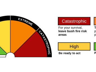
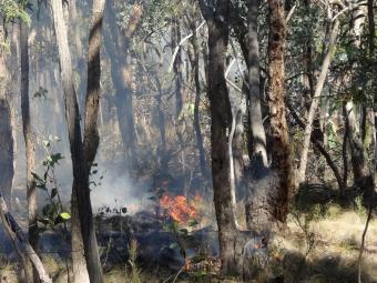
During bushfire season, we temporarily pause services and restrict access to protect our community on extreme or catastrophic fire danger days.
Why we take these steps
While bushfire preparation begins long before an extreme or catastrophic fire danger day, we act on these days to:
- minimise our community’s exposure to potential danger
- protect our staff by reducing their exposure and preventing fire ignition from work activities
- limit traffic and visitor access in bushfire prone areas, so emergency services can respond quickly and safely.
Closures and service changes
Parks and reserves
On extreme and catastrophic fire danger days, these parks are closed:
- Pound Bend Reserve (local road closures apply to discourage nearby parking)
- Jumping Creek Reserve
- Currawong Bush Park (no vehicle access)
Parks maintenance is also rescheduled to happen on a safer day.
Our services
On extreme and catastrophic fire danger days only in bushfire prone areas:
On catastrophic fire danger days only in bushfire prone areas:
Schools and early childhood services
The Victorian Department of Education determines how schools, kindergartens and early childhood services respond to fire danger ratings.
Ask your school, kindergarten or early childhood service provider about their emergency plan.
Businesses, clubs and facilities
Local businesses, clubs and facilities may also close. Please check with them directly.
Key terms
Fire danger period and total fire ban
The Country Fire Authority (CFA) declares these to reduce the likelihood of bushfires starting by placing restrictions on how the community uses fire.
When planning to light a fire, learn about your responsibilities, and check what restrictions are in place.
Read about restrictions:
Bushfire prone areas
Bushfire prone areas (BPAs) are areas that are subject to or likely to be subject to bushfires. The Minister for Building formally designates these areas under the Building Act. Specific construction and planning requirements apply in a bushfire prone area.
An area is designated as a bushfire prone area based on its bushfire hazard level. This is an indicator of how extreme a bushfire can be, based on landscape conditions.
Fire danger ratings
Fire danger ratings tell you how dangerous a fire could be if one started, but not the likelihood of fires starting. They are important because they help you decide what actions to take to protect yourself and others from bushfires and grassfires.
Ratings are forecast using Bureau of Meteorology data for up to 4 days in advance, based on weather and other environmental conditions such as vegetation.
Fires can start on any day, regardless of the rating, so having a plan is always important.
Where do I find the fire danger rating?
Head to CFA - fire danger ratings to find the 4-day forecast. We’re in the Central Fire District.
You’ll also see roadside signs along Heidelberg-Warrandyte Road and Ringwood-Warrandyte Road.
How can you prepare?
As the bushfire experts, the Country Fire Authority (CFA) recommends creating a plan. For templates and helpful advice, head to CFA - plan and prepare.
You can also explore resources we have compiled on Preparing for emergencies.